

Lé bliogue Spatial Analysis présente des cartes dé noms d’riviéthes et tout chenna ès Êtats Unnis et en Grande Brétangne:
Naming Rivers and Places: The number of rivers in the US, combined with Derek’s brilliant design, make this a really compelling map. Inspired by this work I have quickly (with much less cartographic flair) extracted the major rivers and streams in Great Britain from the Ordnance Survey’s Strategi dataset and coloured them according to whether they are a “river”, “canal” (not sure if this really counts in terms of naming), “water”, “afon” (Welsh for river) and “brook”. You can see that a clear geography exists.
En Jèrri j’avons:
In Jersey we’ve got:
- rué = stream
- russé = stream
- canné = stream
- dou = brook
- douettîn/douottîn = small brook
- byi/bié = leat
- stchette = stream which dries up in Summer
- stchez = stream which dries up in Summer
- rangnie = stream betwen rocks at low tide
- bouët = muddy stream (obsolete word found in placenames)
- pèrquage = not strictly a stream, but an access alongside a stream
- plianque = a plank/bridge across a stream
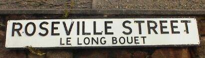
Nou-s’en trouve des noms d’pliaiche et noms d’rue par les c’mîns:
Familiar placenames and roadnames contain some of these elements (sometimes widely known in oldfashioned spelling):
- Lé Stchez (Le Squez)
- Lé Pliat Dou (= the flat brook; Plat Douet)
- Lé Long Bouët (Roseville Street)
- Lé Pèrquage (Castle Street)
- La Plianque Billot (York Street)
- Les Russieaux (Les Ruissieaux)
- Lé Faux Bié (= the false leat; Faux Bie)
- Lé P’tit Dou (= the little brook; Brook Street)